

 Download
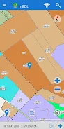
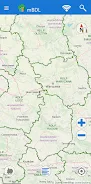
 Introducing the mBDL app - your mobile forest data bank! With this application, you can access forest maps directly on your phone or tablet. The app provides various forest thematic BDL maps, including basic maps, tree stands, ownership forms, forest habitats, plant communities, hunting maps, tourist development maps, fire hazard maps, and more. You also have the option to display raster backgrounds like topographic or aerial/satellite orthophoto maps. The app allows you to download the necessary data for offline work, making it convenient to use in forest districts and national parks even without an internet connection.
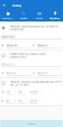
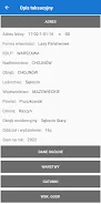
In addition to maps, you can access a full taxation description for forests of all ownership forms, with detailed information on species of trees and shrubs, forest addresses, economic indicators, and more. The app also offers functionalities like area and distance measurement, GPS recording, route recording, and navigation. You can export saved waypoints and routes as KML files and easily share them with others. Searching for forest divisions based on forest addresses, cadastral parcels, or coordinates is also possible. Get acquainted with the app's basic functionalities through the provided manual. Download the mBDL app now on https://www.bdl.lasy.gov.pl/portal/deklaracja-mBDL
Features of this App:
- Direct access to forest maps on phones and tablets.
- Forest thematic BDL maps, including basic map, tree stand, ownership forms, forest habitats, plant communities, hunting map, tourist development map, and fire hazard map.
- Option to display predefined raster backgrounds such as topographic map or aerial/satellite orthophotomap, as well as maps from external WMS services.
- Offline functionality allowing the use of maps for forest districts and national parks even without an internet connection.
- Online access to a full taxation description for forests of all ownership forms, including species of trees and shrubs, detailed description, forest address, economic indications, and more.
- Additional functionalities for area and distance measurement, GPS location recording, route recording, and simple navigation to a given point.
Conclusion:
The mBDL App provides convenient and comprehensive access to forest maps and information. With various thematic BDL maps and the option to display additional raster backgrounds and WMS services, users have a range of map choices. The offline functionality allows for continued use even without an internet connection, making it useful in remote forest areas. Moreover, the App offers detailed taxation descriptions for forests, making it an informative tool for forest owners and enthusiasts. The additional functionalities for measurement, GPS recording, and navigation further enhance the usability of the App. Download the mBDL App now to explore and navigate forests with ease.


- Fortnite: Complete Guide to Oni Masks and Acquisition 3 hours ago
- Roblox: Squid Game Season 2 Codes (January 2025) 4 hours ago
- Pikmin Bloom's Valentine's Event: Love and Chocolate Celebrated 6 hours ago
- Steel Hunters Early Access Date Revealed 6 hours ago
- "Anora: How to Watch Post-Oscar Triumph" 7 hours ago
- Preorder Samsung Galaxy S25 and S25 Ultra Now 7 hours ago
-

Personalization / 1.0.0 / by DigitalPowerDEV / 11.10M
Download -

Video Players & Editors / v1.6.4 / by Vodesy Studio / 62.41M
Download -

Video Players & Editors / v1.02 / by TateSAV / 13.80M
Download -

Productivity / 1.5 / 51.00M
Download -

Lifestyle / 1.5 / by BetterPlace Safety Solutions Pvt Ltd / 9.60M
Download


-
 All Passwords and Padlock Combinations in Lost Records: Bloom and Rage
-
 30 best mods for The Sims 2
-
 Tokyo Game Show 2024 Dates and Schedule: Everything We Know So Far
-
 Best Android PS1 Emulator - Which PlayStation Emulator Should I Use?
-
 Hogwarts Legacy 2 Confirmed: HBO Series Connection
-
 Ultimate Basketball Zero Zones Tier List – Best Zone & Style Combos