

 Download
 Zoom Earth serves as an invaluable tool for tracking hurricanes, typhoons, and tropical cyclones in real-time, offering a comprehensive suite of features that cater to weather enthusiasts and professionals alike. Here's a detailed look at how Zoom Earth can help you stay informed about these powerful storms:
Key Features for Hurricane, Typhoon, and Tropical Cyclone Tracking
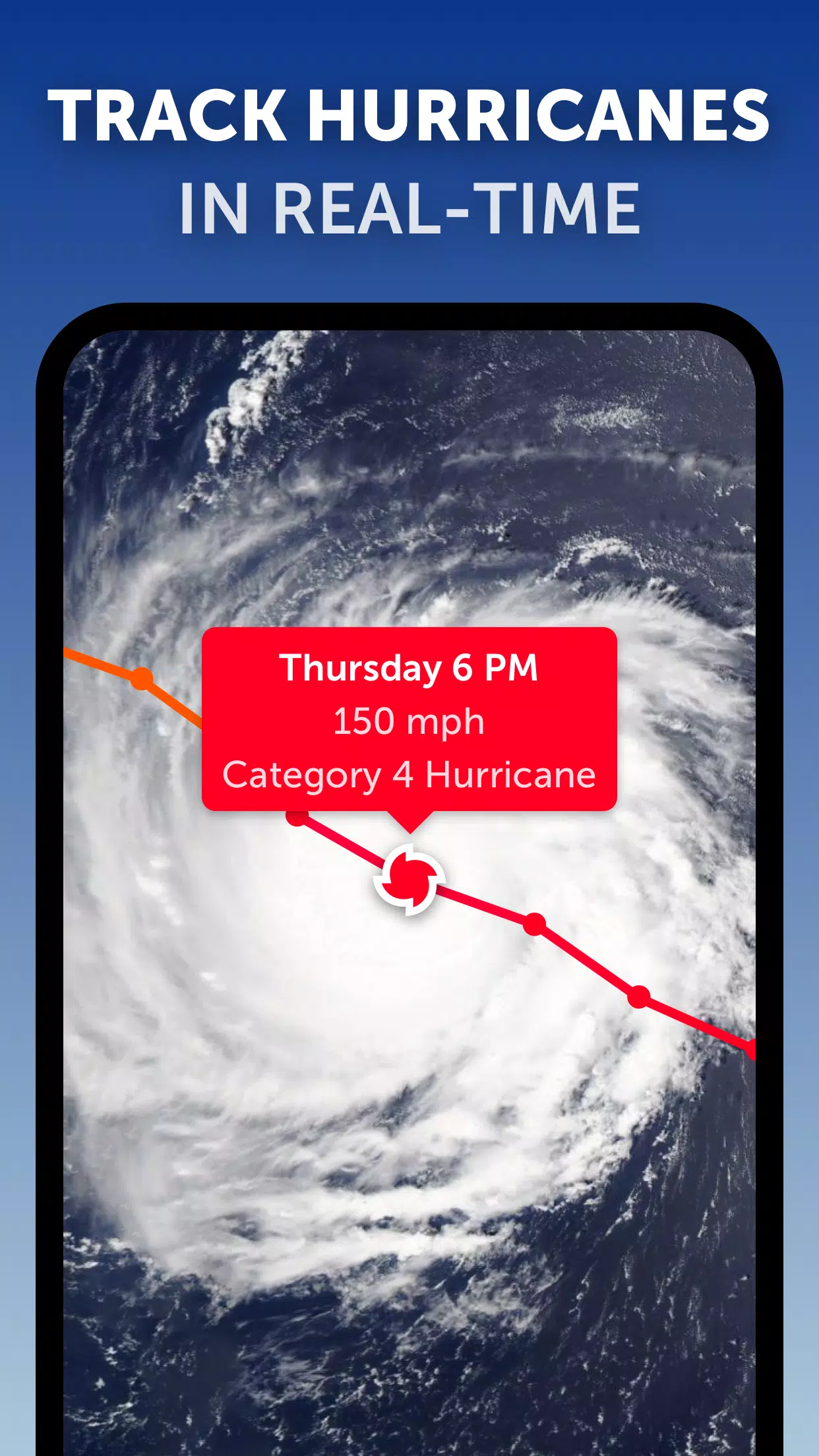
Satellite Imagery: Zoom Earth utilizes near real-time satellite imagery from leading sources like NOAA GOES, JMA Himawari, EUMETSAT Meteosat, and NASA's Aqua and Terra satellites. This imagery provides a clear view of the storm's structure and movement, essential for tracking hurricanes, typhoons, and tropical cyclones as they develop and progress.
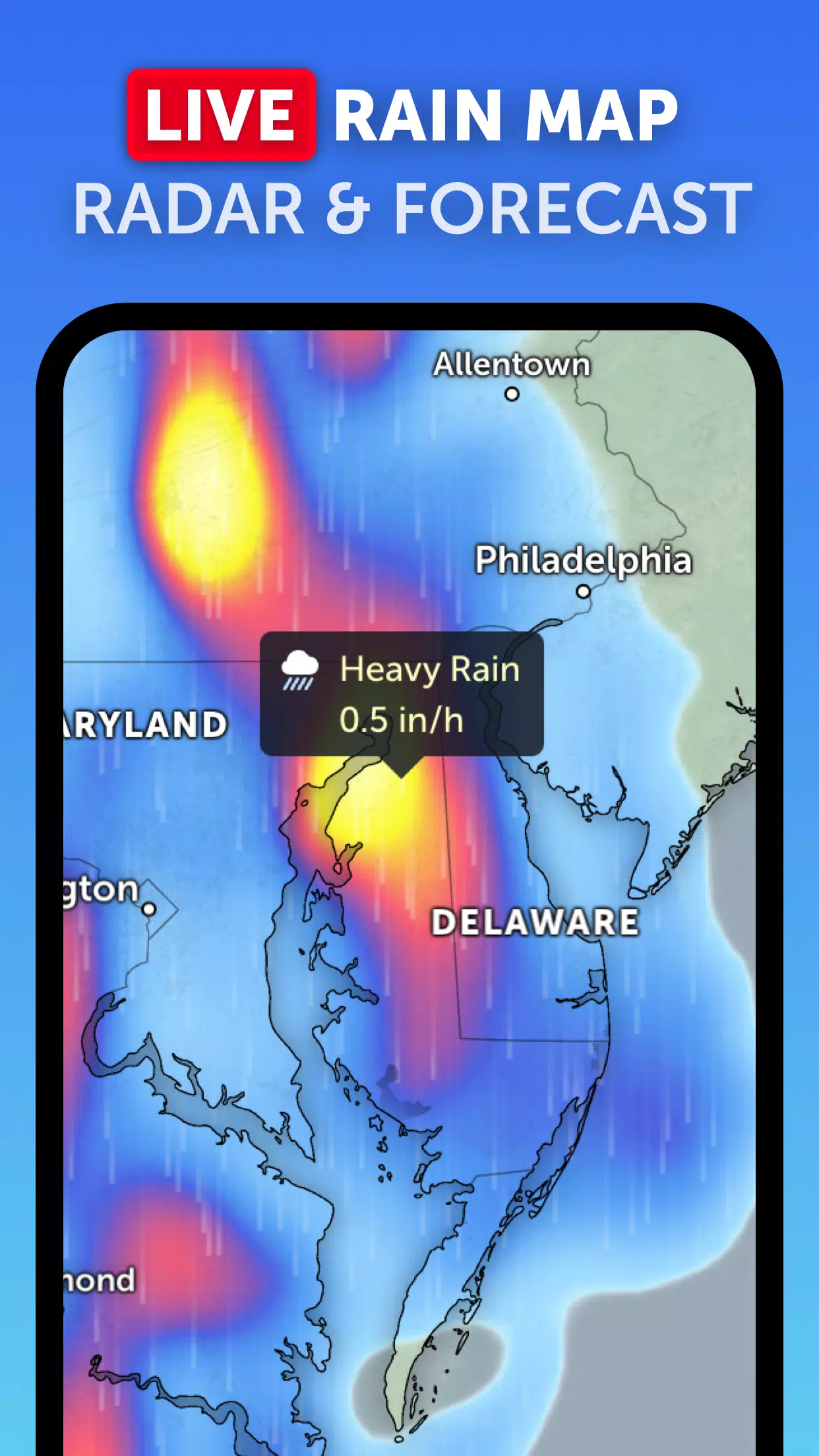
Rain Radar: The platform's weather radar map displays real-time rain and snow data detected by ground-based doppler radar. This feature is particularly useful for monitoring the precipitation associated with these storms, helping you understand their immediate impacts.
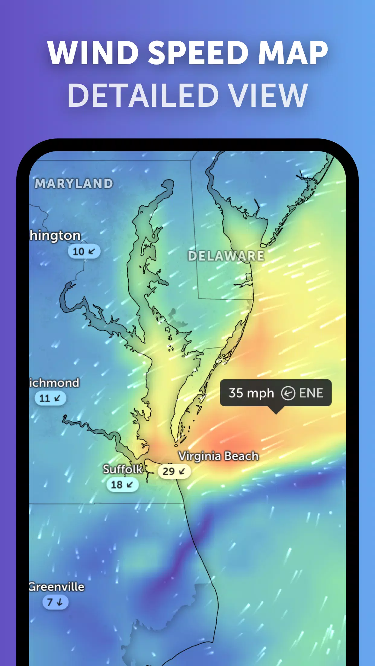
Weather Forecast Maps: Zoom Earth offers interactive visualizations of various weather parameters, including precipitation, wind speed and gusts, temperature, "feels like" temperature, relative humidity, dew point, and atmospheric pressure. These maps provide crucial insights into the forecasted path and intensity of hurricanes, typhoons, and tropical cyclones.
Hurricane Tracking: With its best-in-class tropical tracking system, Zoom Earth allows you to follow these storms from their inception through to their potential escalation to category 5. The platform uses the latest data from reputable sources such as the National Hurricane Center (NHC), Joint Typhoon Warning Center (JTWC), Naval Research Laboratory (NRL), and the International Best Track Archive for Climate Stewardship (IBTrACS), ensuring you have the most current and accurate information.
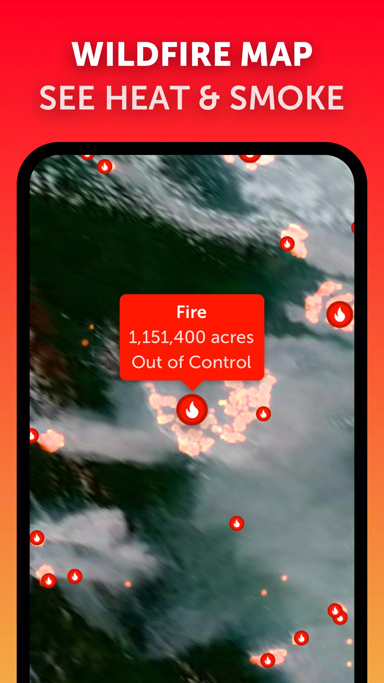
Wildfire Tracking: While primarily focused on weather, Zoom Earth also tracks wildfires, which can be relevant during hurricane seasons when fires may be exacerbated by storm-related conditions. The active fires and heat spots overlay, updated daily with data from NASA FIRMS, helps you monitor these additional hazards.
Customization: Zoom Earth's comprehensive settings allow you to tailor your experience to your preferences, adjusting temperature units, wind units, time zone, and animation styles. This customization ensures that you can view the data in a way that's most meaningful to you.
What's New in the Latest Version 3.1
The latest update, released on September 19, 2024, brings several enhancements to the platform:
- Reduced Clutter: When viewing multiple tropical systems, the interface is now less cluttered, making it easier to focus on the storms you're tracking.
- Separate Alerts: Alerts for Atlantic and Eastern Pacific systems are now separated, allowing for more targeted notifications.
- Improved Map Labels: Enhancements to map labels improve readability and user experience.
By leveraging these features, Zoom Earth provides a robust platform for tracking hurricanes, typhoons, and tropical cyclones, ensuring you have the tools and information needed to stay safe and informed during these potentially dangerous weather events.


-
Best Action Games to Play Now
A total of 10 Hazmob: FPS Gun Shooting Games Mazinger Z salva a Venezuela KOF 2003 ACA NEOGEO ASTRA: Knights of Veda Battle Cats Survivors Stickman Legacy: Giant War Hunting Simulator 4x4 MOLD: Space Zombie Infection Hopeless 3: Dark Hollow Earth Mod Gunship Combat Helicopter Game
-
Nintendo Unveils Switch 1 Direct Before Switch 2 Event
AMD Unveils Next-Gen Laptop Chips Using Last-Gen Architecture
- Epic Seven Reveals Prequel Story, Enhances QoL 1 hours ago
- Top Star Wars Tabletop Games of 2025 2 hours ago
- Supercell's Squad Busters Launches in China 2 hours ago
- Kingambit Joins Pokémon Go in Crown Clash Event Next Month 3 hours ago
- Lysanthir Beastbane Fusion: RAID Shadow Legends Guide 3 hours ago
- Alienware's Area-51 Now Supports RTX 5090 Graphics Card 3 hours ago
- Reviver hits storefronts later this month, letting you remake history with one small change 3 hours ago
- Stumble Guys Unveils Cowboys & Ninjas and Looney Tunes Maps 4 hours ago
- Top Ambush Cookies in CookieRun Kingdom: Tier List 4 hours ago
-

Personalization / 1.0.0 / by DigitalPowerDEV / 11.10M
Download -

Video Players & Editors / v1.6.4 / by Vodesy Studio / 62.41M
Download -

Video Players & Editors / v1.02 / by TateSAV / 13.80M
Download -

Productivity / 1.5 / 51.00M
Download -

Lifestyle / 1.5 / by BetterPlace Safety Solutions Pvt Ltd / 9.60M
Download


-
 All Passwords and Padlock Combinations in Lost Records: Bloom and Rage
-
 30 best mods for The Sims 2
-
 Tokyo Game Show 2024 Dates and Schedule: Everything We Know So Far
-
 Ultimate Basketball Zero Zones Tier List – Best Zone & Style Combos
-
 Best Android PS1 Emulator - Which PlayStation Emulator Should I Use?
-
 Hogwarts Legacy 2 Confirmed: HBO Series Connection